Equipment

List of Equipment

Geophysics Tools

Seismic instrumentation:

  • DAQlink 4 seismograph (SeismicSource) 24 bit multifunction high performance, 24 ch. expandable, equipped with GPS and various accessories
  • Pasi 16S24-U seismograph, 24 ch., equipped with various accessories
  • Pasi Gemini 2 3D surface tromemotro, 24 bit
  • 3D 10 Hz Ambrogeo hole geophone (P and S seismic waves)
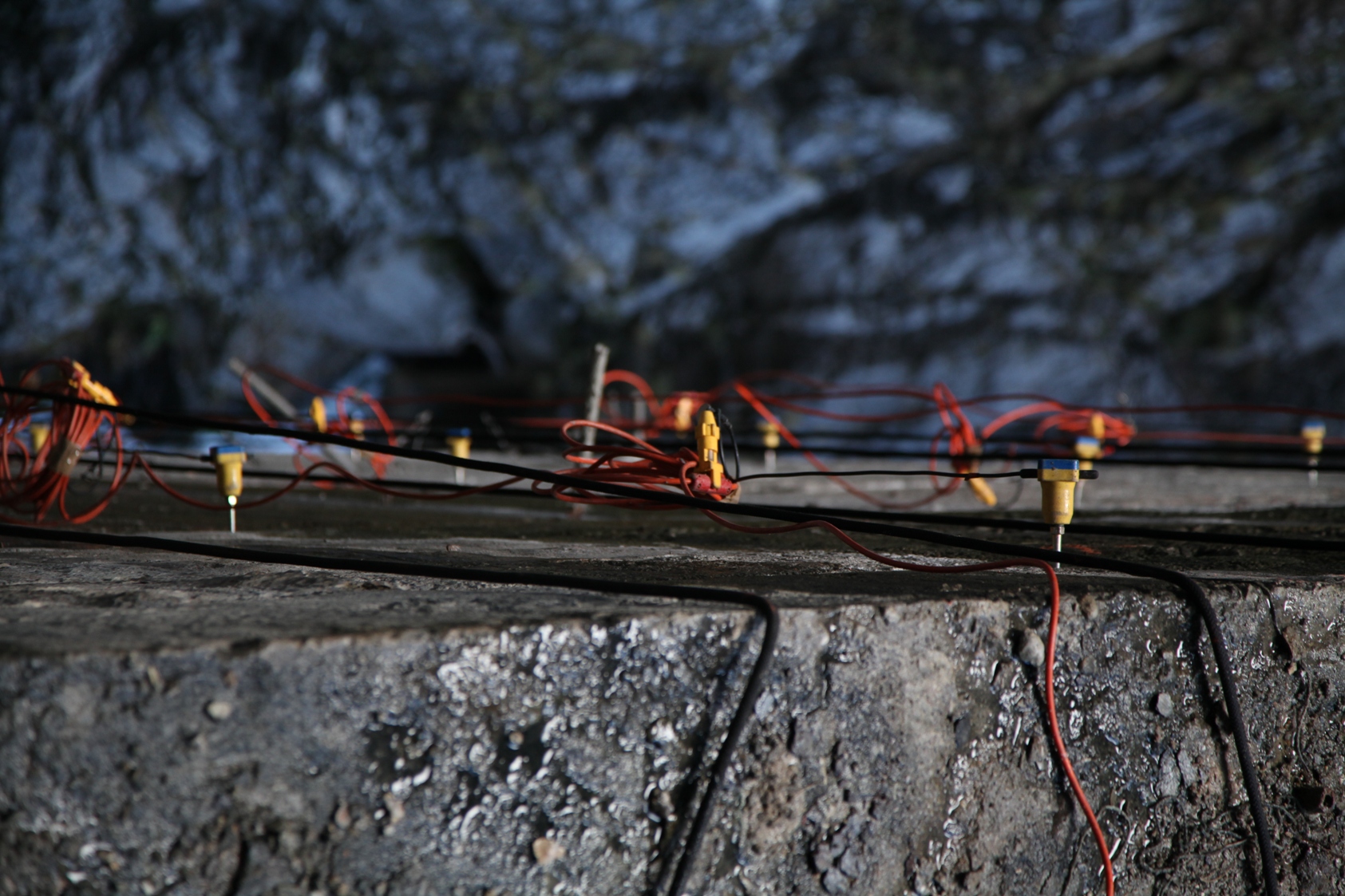
  • Set of 24 high sensitivity 4.5 Hz single clip vertical geophones
  • Set of 24 high sensitivity 10 Hz single clip vertical geophones
  • Set of 24 high sensitivity 4.5 Hz single clip horizontal geophones
  • Set of 24 high sensitivity 100 Hz single clip horizontal geophones
  • Seismic source from Ambrogeo hole (P-S waves)
  • Seismic cannon
  • N.2 seismic cables 75 m range 5 m single clip
  • N.2 seismic cables 130 m range 5 m single clip
  • N.3 batting sleepers (S waves) and energizer
  • N.2 striking plates (P waves) and energizer

Geoelectric instrumentation:

  • ARES II georesistive meter (GF Instruments) 72 ch expandable, automatic 850W – 2000 Vp-p – 5A and various accessories
  • N.2 switch boxes with 48 electrodes each and cascade connection cable
  • N.6 geoelectric cables 75 m range 5.5 m
  • N.72 electrodes

Georadar instrumentation:

  • Georadar MALA Groundexplorer GX with HDR technology, wireless, 450 MHz and 750 MHz antennas, equipped with assembled trolley, GPS and accessories

Other geophysical instrumentation:

  • Wireless Pile Integrity Test (PIT) Novatest P8000 with 24bit wireless accelerometer sensor, tablet, hammer with interchangeable tips
  • CSCOPE MXL4 D underground service finder: high-performance multi-frequency digital locator – multisignal
  • CSCOPE MXT4 multifrequency signal generator for underground service searches

Geotechnical tools

Penetrometric tests:

  • Self-propelled DPSH super-heavy dynamic penetrometer complete with accessories (rods, coatings, various tips, etc.)
  • Probe unit for DPSH
  • SUUNDA DL30 medium dynamic penetrometer complete with accessories (rods, various tips, guides, etc.)
  • Lightweight Technotest TP221 dynamic penetrometer complete with accessories (rods, various tips, guides, etc.)
  • Lever puller for Technotest TP220 / 012 rods

Plate load tests:

  • Equipment for plate load tests from 30-45-60-76 cm up to 250kN
  • Equipment for compression load tests on 1000 kN piles

Soil tests:

  • Earth auger 75cc 5cv with 3 tips 100-200-300 mm and extensions
  • N.2 TECNIX PEN-3960 pocket tubular penetrometers
  • Long rod pocket scissometer PASI S100
  • Short rod pocket scissometer TECNIX SCIS-80
  • Various equipment for on-site determinations

Rock tests:

  • Rock hammer DRC GeoHammer
  • N.4 Scientific geological compasses
  • N.4 Eastwing geologist hammers
  • Profilographer – TECNIX Barton comb

Monitoring:

  • Robotic Total Station Stonex R80 Cube h24, precision 0.5 ″ – 1 ″
  • N.4 control units for automated monitoring
  • N.12 fixed hole inclinometers
  • N.20 wire strain gauges
  • N.2 strain gauges / multi-base hole setters
  • Various crack monitors and crack meters
  • 20 biaxial wall clinometers
  • Various temperature sensors
  • Various weather / rain stations
  • ITMSOIL digital vertical biaxial inclinometer probe, 50m, wireless technology, complete with controller and accessories
  • Phreatimeter PASI BFKT 100m, centimeter round cable, with temperature sensor

Rope investigations:

  • N.6 100m semistatic ropes 10.5
  • N.6 full work harnesses
  • Various equipment: carabiners, descenders, self-locking, anchors, helmets, backpacks, etc.
  • Two-way portable radios and walkie talkies

Topographic survey tools

  • DJI Matrice 300 RTK drone
  • DJI Zenmuse L1 Lidar sensor
  • DJI Mavic Pro drone
  • One Pole Robotic Kit: Stonex R80 Robotic Total Station (accuracy 0.5 ″ – 1 ″), Stonex S900A 800 channel GNSS receiver – IMU, Stonex UT10 Controller
  • Topcon GLS2000 Laser Scanner (120,000 dots / sec – 130m distance range)
  • STONEX S10 GPS and related telescopic rod, GPS / GLONASS / BEIDOU, 220Ch, WCDMA, WIFI, BT
  • Leica TS10 Total Station
  • STONEX S4II C / H portable GPR handheld controller
  • Garmin GPSMAP 64S GPS, GPS and GLONASS receiver, wireless connectivity
  • N.2 BOSH GLM laser distance meters
  • Two-way portable radios and walkie talkies

IT equipment

In the 3 offices in Trieste, S. Stefano di Cadore and Bolzano, IGS srl has 15 fixed workstations with the latest generation Windows operating system, connected to an extremely flexible structure, consisting of servers and 2 NAS, with uninterruptible power supply . The workstations are equipped with a fixed PC or notebook and a 24 ‘monitor. The system can be accessed remotely through the Cloud or VPN provided to employees. The system is connected to A3-A4 multifunction printers and A0 + plotters

Vehicles

  • N.1 Ford Transit long wheelbase van
  • N.1 Mitsubishi L200 truck

Main Softwares

Software for Geophysics

  • ERTLab 64 (geoelectric): finite element inversion and 2D-3D visualization of resistivity and loadability geoelectric data
  • DW Tomo Geogiga Seismic pro (seismic): seismic tomography (inversion using genetic algorithms)
  • ReflexW Sandmeier 2D-3D (seismic-GPR): 2D-3D data processing and interpretation
  • WinMASW Academy Eliosoft (seismic): MASW, ESAC, ReMi, HV, MFA, FVS, RPM, ecc.
  • GeoTom CG (seismic-GPR): 2D-3D data processing and interpretation
  • TomTime (seismic): data processing
  • Front End Geogiga Seimic pro (seismic): data processing
  • Mala Groundvision (GPR): 2D data processing and interpretation
  • Mala 3D Vision (GPR): 2D data processing and interpretation
  • Object mapper (GPR): tracking buried structures
  • Voxler Goldensoftware: 3D modeling
  • Surfer Goldensoftware: 2D-3D modeling
  • Geopsy (seismic): HV
  • Downhole Geostru (seismic): down-hole
  • Downhole Deviometer (seismic): down-hole
  • Easy HV Geostru (seismic): HV
  • Easy MASW Geostru (seismic): MASW
  • Easy Refract Geostru (seismic): refraction seismic
  • LSR 2D STACEC: 2D Local Seismic Response to finite elements
  • STRATA: Local Seismic Response
  • REXEL: Local Seismic Response

Software for Geotechnics and Monitoring

  • Midas GTS NX – CSPFea: 3D geotechnical-geomechanical modeling with finite elements
  • Rocscience: various geotechnical-geomechanical modeling software
  • Rockyfor3D: 3D rockfall modeling
  • Ramms (avalanche, rockfall, debrisflow): modeling of rapid phenomena
  • Bulkheads Plus + VSP module – Harpaceas: flexible support works, analysis of confined and unconfined filtration flows, analysis of global stability with or without reinforcement works (geosynthetics, nails, poles, etc.)
  • SAP 2000: structural calculation
  • GFAS: finite element geotechnics
  • MDC: Design of rigid support works possibly based on poles or tie rods
  • Deep Found Geostru: subsidence of piled slabs
  • Basement: two-dimensional hydraulic modeling
  • HEC-RAS: one-two-dimensional hydraulic modeling
  • Profile Manager – ITMSOIL: inclinometer monitoring
  • Dynamic Probing Geostru: processing of dynamic penetrometric tests, SPT
  • PGS: on-site geotechnical investigations
  • MPA Formula: elaboration of sclerometric measurements on rock
  • Strater Goldensoftware: stratigraphic columns
  • HydroSez: hydrogeology and hydraulic defense works
  • MACRA 1: analysis of watercourses
  • MACRA 2: hydraulic and static checks on weirs and spillways
  • MACSTAR W 4: stability check of reinforced earth works or gabions 
  • MACRO: sizing of support nails
  • Califfo: utility for calculating the bearing capacity of foundations
  • VCASLU: tool for calculating the ultimate strength of pressure-bending sections in reinforced concrete

Software for Hydrology – Hydraulics

  • Lekan: hydrographic analysis and delimitation of basins
  • Hec-HMS: hydrological calculation
  • Hydraulic tool box: hydrological and hydraulic calculations to aid in the design
  • Hec-RAS: 1D and 2D hydraulic modeling of free surface currents, solid transport and debris / mud flow
  • Basement: 1D and 2D hydraulic modeling of free-flowing currents and solid transport
  • DFRM: two-phase cell model for the hydraulic propagation of debris flows
  • Ramms – debrisflow: hydraulic propagation of debris flows
  • EPA SWMM: Hydrological and hydraulic modeling of urban drainage systems
  • EPA NET: Modeling of pressurized hydraulic networks

Cartography and Drawing

  • CAD and GIS drawing and cartography software
  • Cadtools: utility that expands the potential of Autocad with particular reference to the processing of topographic data and the return of 3D models
  • Autosez: plugin for returning quoted sections and profiles in a cad environment
  • Lidar 360 – Green Valley International: Lidar data handling and processing, point clouds
  • Metashape: aerial photogrammetric processing
  • Cloud-Compare: visualization and manipulation of point clouds and meshes
  • Roads – Sierrasoft: BIM, road and river design, land modeling and topographic data processing
  • DTS CAD 2020: topography, road and river design 2D, 3D
  • Thopos CAD: topography
  • GeoGIS Mobile Stonex: topographic data acquisition software
  • Cube-link Stonex: topography
  • Stonex data manager: topography
  • MapSource: map management for GPS

Project Management and planning

  • Nubess ME: assignements and process management, collaborative platform
  • Office 365: collaborative suite
  • Microsoft Project: project management
  • Project Libre: project management
  • Primus – ACCA: calculation and accounting
  • Primus-C – ACCA: documents, specifications and reports
  • Mantus – ACCA: maintenance plan for the work and its parts

Contact us for more informations

IGS s.r.l.
  • Legal and operational address:
    Via del Lazzaretto Vecchio 18, – 34123 Trieste (TS)
  • Operational addresses:
    Vicolo Venaghi, 2 – 32045 Santo Stefano di Cadore (BL)
  • Via Marie Curie, 17 – 39100 Bolzano (BZ)
  • Phone: +39 0435 700191
  • E-mail: info@igs-geo.com
  • PEC (certified email address): igs-geo@pec.it